


Geocode Address at SmartMap Portal and Load It to GIS Software
10 February 2022
SmartMap API is a map-based Application Program Interface (API) that supports standard GIS protocol such as WMS and WFS. Besides it also supports WMTS. It enables SmartMap API to be easily integrated with any GIS software.
One of SmartMap API endpoints are geocoding and reverse geocoding.
Geocoding is the translation of an address into latitude longitude. Meanwhile, reverse geocoding translates latitude longitude to the nearest address.
Geocoding via SmartMap API Portal
The first step in geocoding is uploading the input data in SmartMap API Portal. SmartMap can determine accuracy of the geocoding based on location accuracy such as geocoded on the exact location, geocoded nearby street, section or city.
After the geocoding process completed, you can download the geocoded data in CSV format.
How to use GIS software to overlay geocoded addresses on the TM Malaysia map?
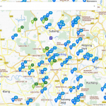
Once the data input has been geocoded, upload the geocoded data in ArcGIS software to view the data that have been selected in SmartMap API Portal. In GIS software, the geocoded data will be displayed as point. Users can overlay geocoded data point locations on top of the SmartMap API WMS basemap layer in GIS software for optimal data visualisation.
- ArcGIS Software
SmartMap Geocoding & Map Data Display Using ArcGIS Software video tutorial will walk you through on how to use geocode features in SmartMap API Portal integrates with ArcGIS software to display the geocoded data.
- QGIS Software
The Geocoding & Displaying Map Using QGIS Software video tutorial will explain on how to use geocode features in SmartMap API Portal integrates with QGIS software to display the geocoded data.
- MapInfo Software
The Geocoding & Displaying Map Using MapInfo Software video link will explore on how to use geocode features in SmartMap API Portal integrates with MapInfo software to display the geocoded data.
Geocode data and display the data on map in ArcGIS Software
How to perform geocoding process directly in ArcGIS software?
Users must install and activate the SmartMap Tools inside the ArcGIS software catalogs to begin the geocoding process. When uploading data, ensure it can be geocoded and enter the API keys in ArcGIS software. The geocoded data will be automatically plotted in ArcGIS software once the geocoding process is complete. Users can overlay geocoded data point locations on top of the SmartMap API WMS basemap layer in ArcGIS software for optimal data visualisation.
The Geocode Data in ArcGIS Software video tutorial link will demonstrate on how to use geocode features in ArcGIS Software with enabling SmartMap Tools.
Connect SmartMap WMS Server in BI Software
Tableau Software
How to connect TM Malaysia Map in Tableau?
Tableau is a business data visualization application used for business analysis. Connect the SmartMap WMS basemap layer as a background map in Tableau Desktop to view the TM Malaysia Map. Tableau Desktop could fetch data from SmartMap API POI end point via the web data connector. To begin, enter the web data connector URL and your SmartMap API POI request URL into the web data connector. Once complete, the data from SmartMap API POI end point can be displayed in Tableau Desktop in table form.The Get Connected to the WMS Server in Tableau Software video tutorial will show you in how to connect the SmartMap WMS basemap layer in Tableau Desktop to display the geocoded data and POI end point.
Related Posts
TM SmartMap Site Performance helps grow your business by ranking your physical outlets based on 3 cr...
Plan your trip efficiently with Trip Planner by TM One SmartMap. Besides places to visit, our planne...
Find your next branch or site planning with Malaysia Datasets using TM One SmartMap Site Selection.