SmartMap

blog_

Methods to Gain Reliable and Accurate Geospatial Data in Tm Malaysia Map

Methods to Gain Reliable and Accurate Geospatial Data in Tm Malaysia Map

28 January 2022
SmartMap is a geospatial analytics tool that makes use of the first Malaysia digital map launched by Telekom Malaysia Berhad™ in 2011. TM Malaysia map has been one of the maps that focuses on geospatial data. The data such as points of interest (POI), property types, addresses, streets, demographics, and many more. We’ve created several methods for gathering reliable and accurate data into the TM Malaysia Map.
Geospatial data in optimizing businesses to make the right decisions
 

Geospatial data may be used by businesses to enhance and preserve their target market. Customers’ preferences can be discovered from the data and help businesses figure out how well their business will do in a specific location. Customers in different locations may have various interests in your products and services. Hence, you may open a business in a location where most people are interested in what you offer.

Data sources gathered divided in a few categories
 

Continuous map updating is our top priority at TM with a constant schedule and method to ensure data quality and accuracy. As a result, our customers may feel more confident when planning, marketing, and managing their businesses with SmartMap.

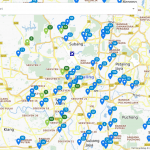
The data sources gathered are divided into three categories: gathered content, map feedback, and surveys.

Gathered Content
Property Developers

  • Provides information about new developments and real estate developments in a specific location to TM
  • Real estate investors, franchisees, and retailers can all benefit from the information that developers provide.
Web-Based Information Systems

  • The POI (point of interest) can be updated by extracting data from well-known websites as reference.
Map Feedback
TM Staff & Customers Feedback

  • For our internal team to give feedback on maps, we created internal TM Online Map system.
  • The opinions of users are important since they may be familiar with the location.
  • Feedback from users will be used to update locations and POI that have not been updated.
Survey
Survey Teams

  • In areas where TM does not have a base map, a survey team is assigned to do an investigation.
  • A scheduled survey will be carried out under the supervision of a supervisor to minimize costs and update the map efficiently.
Mobile Imaging Systems

  • Gather field data in a more efficient, precise, and safe manner by capturing 360-degree geographical images.
  • Captures street photos, GPS tracks, and routing data.
Unmanned Aerial Vehicle (UAV)

  • Capture an aerial view of an area for a quick update, particularly in areas where TM does not have a base map
error: