


Satellite Imagery as A Measure to Update SmartMap
9 February 2022
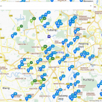
SmartMap is one of Malaysia’s most comprehensive maps where data update is released quarterly to our customers. The challenge that TM faces in updating SmartMap is to know where the data need to be updated. TM is exploring using satellite images to detect changes on the ground especially when there are new constructions.
Compare changes of map with algorithms for Satellite Imagery
TM has done research using three different algorithms in detecting changes on the ground.
The three algorithms are:
- Mean Squared Error (MSE)
- Structural Similarity Index (SSIM)
- Image Hashing and Levenishtein Distance
Summary of the algorithm performance and accuracy result:
| Performance (speed) | ||||||
| Accuracy (error) | ||||||
| Summary | ||||||
Details research on detecting on the ground changes using satellite imagery can be read here.
Related Posts
Batch Geocode Service With TM ONE SmartMap & Visualize In QGIS
TM ONE SmartMap API as the geocoder to batch geocode and visualize in QGIS the data results.
TM ONE SmartMap API as the geocoder to batch geocode and visualize in QGIS the data results.
Malaysia Population Density by State With TM One SmartMap
Explore the detailed Malaysia population density by state, district and mukim with TM One SmartMap b...
Explore the detailed Malaysia population density by state, district and mukim with TM One SmartMap b...
High Rise Building Address
High rise building address data or also known as Multi-Storey Address (MSA) data refers to location ...
High rise building address data or also known as Multi-Storey Address (MSA) data refers to location ...